Wind engineering
November 12, 2013 at 10:17 PM by Dr. Drang
When I first heard reports about the wind speeds in Typhoon Haiyan, I assumed it was case of journalists getting their facts wrong. But as those early reports were repeated, and as I saw photos of the devastation, I realized that the initial reports weren’t wrong—Haiyan was an unbelievably powerful storm.
Twenty years ago, I was part of a team working in Florida to assess structural damage after Hurricane Andrew. Every day, I’d have a list of addresses to visit, where I’d climb through broken buildings, taking photos, measurements, and notes documenting the damage that I’d later analyze. As I drove to the building sites, I’d often pass debris from destroyed houses that had been piled up along the roads. I didn’t arrive in Florida until maybe two months after Andrew. Colleagues who’d been there longer told me that I was seeing a faint echo of the early days of the cleanup; when they first arrived, there were windrows of debris along many streets, piled as high as the front end loaders could reach. And we weren’t even in the areas that were hardest hit.
At the time, meteorologists thought Andrew’s wind speeds were about 150 mph—later analysis showed it was more like 165 mph when it made landfall in Homestead. In contrast, Haiyan’s wind speeds are currently estimated to have been 195 mph.
What’s another 30 mph? That’s only an 18% increase. Well, wind pressure, which is what pushes against buildings and damages them, doesn’t increase linearly with wind speed—it increases with the square of the wind speed. So Haiyan’s pressures were 40% higher than Andrew’s. The buildings I saw 20 years ago that had only had their roofs taken off by Andrew would’ve been flattened by Haiyan.
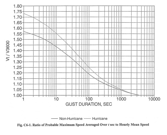
The numbers get higher the more you study them. The 165 mph for Andrew and 195 mph for Haiyan are “sustained” wind speeds, which means they’re averaged over a minute. Gusts can be much higher. Current building codes in the US are based on three-second gusts, the peak wind speed when averaged over a three-second period. The statistical techniques for estimating the peak three-second gust from wind speeds averaged over longer periods have been boiled down into this chart:
The upper curve is for hurricanes, which have been found to be gustier than other winds. The value of the upper curve at 60 seconds is 1.325, and the value at 3 seconds is 1.67. The ratio of these, 1.26, is the estimated ratio of the three-second gust speed to the one-minute sustained speed. Thus, Haiyan’s peak gusts may have been as high as 245 mph. That’s tornado-level wind.
If you don’t live in the middle of the country, you may think of tornados as those storms that destroy trailer parks, but that isn’t giving them their proper respect. The winds in a tornado are typically much higher than those in a hurricane. Residential building codes are written to protect against most hurricanes; they don’t even try to handle tornados. A house’s primary protection against tornado damage is the extremely small probability that a tornado will hit it.
It’s the relatively small size of tornados that is their saving grace. If they were as big as hurricanes, the Midwest would be uninhabitable, because we’d be having Haiyans every year. I’m sure there’s a good meteorological reason tornados aren’t as big as hurricanes. I don’t know what that reason is, but I’m glad it’s there.
There are many charities working to help Haiyan’s victims. Use your head as well as your heart when deciding where to send your money. I like Doctors Without Borders.

